History
of Innisfail
Location
and identification
The town of Innisfail with a population of about 9000, is the centre
of the Cassowary Coast Regional Council, containing 19000
people. It is on the Cassowary Coast (named after the rare local
native bird ) between the World Heritage Rainforest and Barrier
Reef areas.
Proposed town
symbols are Rain, River and and Diverse Cultures, and the Shire's
floral emblem is the hibiscus tileacus or coastal cottonwood.
 Original
Inhabitants and their Fate Original
Inhabitants and their Fate
The original inhabitants of this Innisfail region were the
five clans of the Mamu people, following seasonal migratory lifestyles
throughout the rainforests, and moving along the rivers in string-bark
canoes. Among these, the "Cassowary” people (Dugulbarra clan), distinguished
by headdresses of scarlet and yellow feathers, were centred
on the Tchuken Bora Ground on Jordan Creek, off the Johnstone
River.
Today the Jirribal people still occupy their original territory
at Murray Upper, south of Tully, maintaining the Dyirbal language dating back perhaps 40,000 years. The Djiru people continue to live on country around Mission Beach, the Gulngay people around Tully area and the Girramay people at Cardwell. These Aboriginal people resisted the occupation of their
lands vigorously.
The
first incursion came in 1872. Survivors of the shipwreck "Maria" arrived
on the coast near the Johnstone River. Some of the indigenous
people helped; others they opposed. Sub-Inspector Robert Johnstone's
search party came to rescue survivors and punish Aboriginal people
who had abused them, and ventured up river from what are now
Flying Fish and Coquette Points.
Johnstone wrote glowing reports
of the area, and with vigilante Native Troopers attacked the
Mamu people with rifle fire as he escorted the explorer Dalrymple,
charting the watercourse and having it named after himself.
When European
cedar cutters and Chinese gold seekers arrived later in the 1870s
and early in the 1880s, the Mamu fought them and inflicted serious
casualties. Again the Europeans sent in the Native Police. Superior
firepower broke up the indigenous communities and dispersed or
integrated the remaining original landowners.
Settlement
and Development
European settlement, with its Asian and Pacific components, began
late in the region, partly because of Aboriginal resistance. The
Edmund Kennedy exploration of 1848 revealed impenetrable rainforests,
confining European economic enterprises to Pacific coastal waters,
mostly to pearling and trepang collection.
The
first permanent town was established on the southern borders
of the rainforest in 1864, at Cardwell. During the 1870s, the
opening of the Palmer goldfields and other mineral discoveries
brought an inrush of multi-cultural but Anglo-Celtic dominated
settlers to the north of what became the Johnstone Shire, leading
by 1876 to the establishment of Cairns.
Meanwhile,
partly to rescue the goldfields, a variety of agricultural enterprises
were developed in these southern and northern areas. Innisfail
itself (called Geraldton until 1911) was founded in 1880 by Thomas
H.Fitzgerald who took up a 10000 hectare land grant funded by
the Catholic Bishop of Brisbane and All Hallows' Sisters of Mercy.
With 10 Irish and 35 South Sea Islanders as workers, he began
planting sugar cane in the cleared rainforest lands, but not
with personal success.
Those who
followed him did better and the community began to grow rapidly
on the proceeds of sugar production. The Mourilyan mill was built
in 1882, the Babinda mill in 1914, and South Johnstone mill in
1915.Thus sugar drove the growth of predominantly European Innisfail
and still exerts a major influence.
 Multi-cultural
Settlers Multi-cultural
Settlers
The settlers who moved into this region from 1889 were exceptionally
diverse. The first influential group were Anglo-Celtic, but they
were outnumbered by "Kanaka " South Sea Islanders. Aboriginal
and Torres Strait workers, Chinese miners who developed the banana
industry and retail businesses. French merchants, and German timber
and sugar producers.
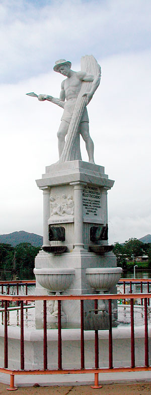
A large Italian
migration began before WW1 and continued into the 1930s and post
WW2; much of Innisfail's present culture is of Italian derivation,
including the evocative Canecutter Monument on the river Esplanade,
adjacent to River Reflections sculptures and their visual histories.
Spanish migrants
produced the currently world famous Paronella Park tourist attraction
as well as, during the 1930s, the first hydro-electric power
plant in Northern Queensland. There were also waves of migration
from Greece, Malta, Yugoslavia, India, Pakistan and the Philippines.
The last big wave came from the border highlands of Laos (following
the Vietnam War) with the Hmong refugees. By 1996, Johnstone
Shire residents spoke 47 different languages along with English.
Main Features
at Present
The introduction of the sugar industry opened a new economic era
in the region. However, this region today is Australia's largest
producer of bananas, rivalling sugar as an income earner. Tea,
papaws and exotic tropical fruits also are grown.
Beef
cattle are processed in a modern abattoir near Innisfail for
domestic and overseas markets. Aquaculture also plays an important
part in the region's economy, ranging from prawn, barramundi
and fresh water crayfish to crocodile farming.
A large prawn
and reef fishing fleet boosts the economy. As well, the Innisfail
region is being recognised as one of the best recreational fishing
areas - from chasing the elusive barrumundi in the estuaries
to game and reef fishing on the Great Barrier Reef and adjacent
island. Manufacturing industries include a large foundry, plastic
products, farm implements and transport equipment.
The incredible
natural beauty of the region from the Great Barrier Reef and
nearby tropical islands to the World Heritage Rainforests, coupled
with the warm tropical climate allowing year-round recreation,
has encouraged tourism and associated development, complementing
the existing economic base. The newest expanding primary industry
with long-term benefits for sustainable agriculture is millable
timber.
The region
is gradually becoming aware of the benefits of cultural and eco
tourism, relying on the diversity of people, food and art forms
and nature in the area. Paronella Park at Mena Creek has led
the way, winning many awards and being promoted in a national
cultural tourism campaign.
Mission Beach
offers top -quality tourist attractions. Massive development
in Townsville and more specifically in Cairns, where billions
of dollars are being invested, is now having a flow-on effect
into this region. Local control is being encouraged in order
to preserve the authentic culture of the Shire.
|